

1838 Original Govt Survey Map - Presettlement
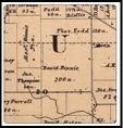
1862 Plat Map of David Binnie Farm (200 Acres)
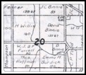
1871 Plat Map of David Binnie Farm (192 Acres)
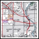
1954 Plat Map of David Binnie Farm (160 Acres)

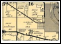
1928 Plat Map of David Binnie Farm (192 Acres)
David Binnie came from Scotland in 1848 with his wife Christina To America. He built a home where the fire station now exists at the corner of Sleepy Hallow Road and Route 72. He had sons, John (1840), David (1848) both born in Ireland, James (1851), Henry (1855), Sandy (1857) were born In Illinois. He had Ellen (1845) in Ireland and Elison (1853) was born in Illinois. John joined the 52nd volunteers in Civil War with Dundee Regiment for 3 years.
David Binnie died on September 12, 1873 and buried in Dundee Township Cemetery West (Rt 31). Farm continued as David Binnie likely the son??? Note family moved north on Sleepy Hallow Road near the entrance to Schweitzer Woods today.
Emily Schweitzer purchased the Binnie Farm about 1954 from Binnie Family. Built her home and a kennel for her beloved Irish Setters. She and her mother moved from Northbrook, Illinois after her father died in 1949.
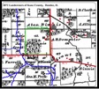
1992 Plat Map showing KCFP owner (134 Acres)
Emily Schweitzer retaining her home (24 Acres)
Emily donated her property to Kane County Forest Preserve in 1990 with agreement that she could live on the property until she passed away. She died in 2002
Map shows six buildings near the river. It was reported that a native american village was located vary close to the river before the settlers arrived after the Blackhawk War in 1832. the village was likely Potawattomi.